Fort Hetzel Cherokee Internment Site
Fort Hetzel Historical Marker
This article is adapted from "Cherokee Removal: Forts Along the Georgia Trail of Tears" by Sarah H. Hill.
Information on Ft. Hetzel has come primarily from the National Archives reports of the Quartermaster’s Department and the microfilm rolls of Cherokee removal located at the archives branch in East Point, Georgia. Local Trail of Tears member Leslie Thomas has investigated numerous leads. In addition, two county histories by Lawrence L. Stanley have been published and are considered valuable by local contacts: The Gilmer County Area of Georgia 200 Years ago and Pages from Gilmer County History 1832-1977 and A Little History of Gilmer County. George Gordon Ward’s Annals of Upper Georgia Centered in Gilmer County includes the names of many early white settlers and local landmarks, and a sketch of Ft. Hetzel based on “careful research by the Author and artist, Robert C. Adams.” Ward claims “the severely simple fort stood until about 1868.”clxxii The books by Stanley and Ward both contain excerpts from the 1835-38 day book kept by store owner Coke A. Ellington.
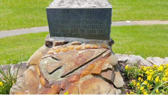
Sometime prior to 1984, Lawrence Stanley placed a stone and granite boulder marking the place he believed to be the site of Ft. Hetzel, at the intersection of Yukon Road and Highway 515, now occupied by Wal- Mart (Illustration 16. Fort Hetzel marker). When grading for road construction was about to destroy the site, Stanley moved the boulder about a mile away to the intersection of 1st Street and Highway 515, where it now stands. A local resident recalls that the Georgia Department of Transportation managed the road construction, but contacts at DOT have no record of recovering archaeological materials from the site. Stanley and Ward are both deceased and efforts to discover their sources have been unsuccessful.
Ellijay.
The town of Ellijay in the Appalachian province was made the county seat of Gilmer in 1834, just two years after the county was created. By the time of removal, it had a courthouse, stores, a post office, and residences. Ellijay was a Cherokee settlement known as elatse yi (fresh green vegetation), or some variant, at least since the eighteenth century, and in the early nineteenth century was included in the Cherokee Nation district of Coosawattee. The white settlement developed on the west bank of the Ellijay River at its junction with
the Cartecay. Since the joined streams become the Coosawattee River, Ellijay stood at the head of an important waterway where many Cherokees lived. Whites began moving into the area in greater numbers as soon as the county was created and gold was discovered. As indicated by the accounts in the Coke Ellington Day Book, whites and Cherokees lived, or at least shopped, virtually side-by-side until the commencement of removal. White Path, one of the most prominent leaders in Cherokee history, lived just north of Ellijay and died on the Trail of Tears in Hopkinsville, Kentucky.
Other Cherokee settlements in the area included Board Town on the upper Ellijay, Mountain Town, Turnip Town (now White Path), Cartecay, and Cherry Log. According to the 1836 evaluations, 20 Cherokee families owned improvements in Mountain Town, 10 at Turnip Town (including White Path), and five on the Ellijay River.clxxiii Many improvements were never evaluated, as is mentioned frequently in the Cherokee claims submitted from the Indian Territory, so we can be confident that many more Cherokees lived in and were removed from the area.
Military Occupation.
The military occupation of the Ellijay post began in the fall of 1837. Capt. William Derrick, who had been called into service in 1836 and stationed at New Echota since then, was ordered to proceed “to the neighborhood of Jones’s” near Ellijay to select a suitable position for the post. Derrick was accompanied by his mounted company including Pvt. James J. Field, quartermaster.clxxiv Further research may identify Jones, who has remained elusive in county courthouse records to this point. On Oct. 7, 1837, Derrick was positioned near the mouth of the Ellijay River.clxxv As with other posts from Dahlonega east to the North Carolina border, Derrick was assigned to the Eastern Military District under the command of Gen. Abram Eustis.
At Derrick’s request, Ft. Wool quartermaster Cox selected the site for his post, which Cox named in honor of supervising quartermaster Lt. A.R. Hetzel. Cox acknowledged that the site, located on the Cartecay River about one mile east of the courthouse, was “objectionable in the military point” but had good access to wood, water, and forage.clxxvi If Cox’s assessment of the distance was correct, the post stood somewhere in East Ellijay. In mid-March, 1838, Capt. Donaldson’s infantry company joined Derrick’s mounted company at Ft. Hetzel, bringing the number of militia to well over one hundred.clxxvii
At least one local resident agreed with Cox’s assessment of the objectionable site. William Cole wrote the governor on March 1 that the troops were stationed at a most inconvenient location where they could protect neither the town nor the countryside. With evident dismay Cole’s reported that the commanders failed to send scouts to watch Indian “maneuvering” and actually told the Indians they had come to protect them.clxxviii
Following the capture and removal of Indians, Derrick was ordered to relieve Capt. John Dorsey at Ft. Newnan, and to arrest him if necessary.clxxix Such orders indicate the extent to which Derrick had earned the respect of his commanding officers. Although Derrick’s was one of only two companies still in service on July 9, he apparently had been mustered out by July 19, 1838.clxxx
Construction.
Following the assignment of commands, Derrick’s first orders were to erect huts and stables for the company and other buildings as necessary, “according to the plan herewith furnished.” The same orders were issued at the same time to Capt.
Ezekial Buffington, and, as in other cases, no plan remains in the collection of military correspondence.clxxxiNo other comments about construction at Ft. Hetzel have been found to this point, but we can assume Derrick built storage facilities for subsistence, forage, and munitions. In late March, quartermaster Field reported that he had cut a road from Coosawattee (Ft. Gilmer and the Federal Road) to Ft. Hetzel, thereby diminishing the travel and transport time from southern points.clxxxii
More...
Information on Ft. Hetzel has come primarily from the National Archives reports of the Quartermaster’s Department and the microfilm rolls of Cherokee removal located at the archives branch in East Point, Georgia. Local Trail of Tears member Leslie Thomas has investigated numerous leads. In addition, two county histories by Lawrence L. Stanley have been published and are considered valuable by local contacts: The Gilmer County Area of Georgia 200 Years ago and Pages from Gilmer County History 1832-1977 and A Little History of Gilmer County. George Gordon Ward’s Annals of Upper Georgia Centered in Gilmer County includes the names of many early white settlers and local landmarks, and a sketch of Ft. Hetzel based on “careful research by the Author and artist, Robert C. Adams.” Ward claims “the severely simple fort stood until about 1868.”clxxii The books by Stanley and Ward both contain excerpts from the 1835-38 day book kept by store owner Coke A. Ellington.
Sometime prior to 1984, Lawrence Stanley placed a stone and granite boulder marking the place he believed to be the site of Ft. Hetzel, at the intersection of Yukon Road and Highway 515, now occupied by Wal- Mart (Illustration 16. Fort Hetzel marker). When grading for road construction was about to destroy the site, Stanley moved the boulder about a mile away to the intersection of 1st Street and Highway 515, where it now stands. A local resident recalls that the Georgia Department of Transportation managed the road construction, but contacts at DOT have no record of recovering archaeological materials from the site. Stanley and Ward are both deceased and efforts to discover their sources have been unsuccessful.
Ellijay.
The town of Ellijay in the Appalachian province was made the county seat of Gilmer in 1834, just two years after the county was created. By the time of removal, it had a courthouse, stores, a post office, and residences. Ellijay was a Cherokee settlement known as elatse yi (fresh green vegetation), or some variant, at least since the eighteenth century, and in the early nineteenth century was included in the Cherokee Nation district of Coosawattee. The white settlement developed on the west bank of the Ellijay River at its junction with the Cartecay. Since the joined streams become the Coosawattee River, Ellijay stood at the head of an important waterway where many Cherokees lived. Whites began moving into the area in greater numbers as soon as the county was created and gold was discovered. As indicated by the accounts in the Coke Ellington Day Book, whites and Cherokees lived, or at least shopped, virtually side-by-side until the commencement of removal. White Path, one of the most prominent leaders in Cherokee history, lived just north of Ellijay and died on the Trail of Tears in Hopkinsville, Kentucky.
Other Cherokee settlements in the area included Board Town on the upper Ellijay, Mountain Town, Turnip Town (now White Path), Cartecay, and Cherry Log. According to the 1836 evaluations, 20 Cherokee families owned improvements in Mountain Town, 10 at Turnip Town (including White Path), and five on the Ellijay River.clxxiii Many improvements were never evaluated, as is mentioned frequently in the Cherokee claims submitted from the Indian Territory, so we can be confident that many more Cherokees lived in and were removed from the area.
Military Occupation.
The military occupation of the Ellijay post began in the fall of 1837. Capt. William Derrick, who had been called into service in 1836 and stationed at New Echota since then, was ordered to proceed “to the neighborhood of Jones’s” near Ellijay to select a suitable position for the post. Derrick was accompanied by his mounted company including Pvt. James J. Field, quartermaster.clxxiv Further research may identify Jones, who has remained elusive in county courthouse records to this point. On Oct. 7, 1837, Derrick was positioned near the mouth of the Ellijay River.clxxv As with other posts from Dahlonega east to the North Carolina border, Derrick was assigned to the Eastern Military District under the command of Gen. Abram Eustis.
At Derrick’s request, Ft. Wool quartermaster Cox selected the site for his post, which Cox named in honor of supervising quartermaster Lt. A.R. Hetzel. Cox acknowledged that the site, located on the Cartecay River about one mile east of the courthouse, was “objectionable in the military point” but had good access to wood, water, and forage.clxxvi If Cox’s assessment of the distance was correct, the post stood somewhere in East Ellijay. In mid-March, 1838, Capt. Donaldson’s infantry company joined Derrick’s mounted company at Ft. Hetzel, bringing the number of militia to well over one hundred.clxxvii
At least one local resident agreed with Cox’s assessment of the objectionable site. William Cole wrote the governor on March 1 that the troops were stationed at a most inconvenient location where they could protect neither the town nor the countryside. With evident dismay Cole’s reported that the commanders failed to send scouts to watch Indian “maneuvering” and actually told the Indians they had come to protect them.clxxviii
Following the capture and removal of Indians, Derrick was ordered to relieve Capt. John Dorsey at Ft. Newnan, and to arrest him if necessary.clxxix Such orders indicate the extent to which Derrick had earned the respect of his commanding officers. Although Derrick’s was one of only two companies still in service on July 9, he apparently had been mustered out by July 19, 1838.clxxx
Construction.
Following the assignment of commands, Derrick’s first orders were to erect huts and stables for the company and other buildings as necessary, “according to the plan herewith furnished.” The same orders were issued at the same time to Capt. Ezekial Buffington, and, as in other cases, no plan remains in the collection of military correspondence.clxxxiNo other comments about construction at Ft. Hetzel have been found to this point, but we can assume Derrick built storage facilities for subsistence, forage, and munitions. In late March, quartermaster Field reported that he had cut a road from Coosawattee (Ft. Gilmer and the Federal Road) to Ft. Hetzel, thereby diminishing the travel and transport time from southern points.clxxxii
More...