Fort Cedartown Cherokee Internment Fort
Cedartown, GA
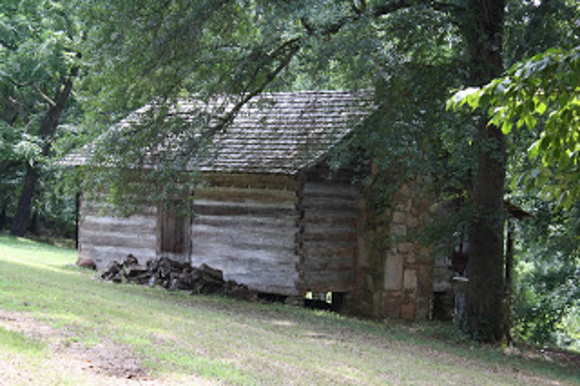
Cabin located along Cedar Creek. Image source: http://trailofthetrail.blogspot.com/2010/08/driving-tour-trail-of-tears-from.html
This article is adapted from "Cherokee Removal: Forts Along the Georgia Trail of Tears" by Sarah H. Hill.
Vincent’s provision returns indicate that
he initially captured 153 Indians, a number that
increased gradually over the next several days.
Provisions were distributed to 153, then to 163,
166, and finally to 199 captives. On June 12, the
number dropped sharply to 18 Indians,
presumably those too sick to travel, and that
number remained stable until June 26.
Driving the Trail
The driving tour begins at the intersection of Wissahickon Road and Cave Spring Road (N 34’00.874 / W 85’15.508). The original route veered a bit to the east and west of the modern road, but went generally the same direction. At about 1.94 miles, at about 1201 Cave Spring Rd. (N 34’02.349 / W 85’16.341), the original road veered to the northwest, toward Cedar Creek, and the original road bed can still be seen in a pasture. Field surveyors noted a Cherokee residence that was located here in the 1830s. Travelers crossed the creek just north of that residence, and you can now pick up the path on the opposite side of the creek, at about what is now 294 Seab Green Road (N 34’02.512 / W 85’17.064). To drive to this area from Cave Spring Road, drive approximately 1.36 miles from where the previous “original route” segment ended, then turn left onto Seab Green Road. When you drive across the Cedar Creek bridge, if you look to the south, you can see the shoals where the original road crossed the water. The Seab Green Road segment is approximately .44 miles long, paralleling Cedar Creek.
Drive back out to Cave Spring Road and turn left. The next 1.54 miles, heading north, paralleling the scenic Cedar Creek, are congruent with the original Cherokee-era road. At the bend in the creek, at about .12 miles past the Seab Green Road / Cave Spring Road intersection, you can see a log structure on Cedar Creek’s northeast bank (across from 1900 Cave Spring Road, at about N 34’03.155 / W 85’13.246).
At the intersection of Cave Spring Road and King’s Bridge Road, the original Cherokee-era road veered to the north, through what is now a little less than two miles of woods and fields. In some places along this section, the original road cuts are still visible, and in one quarter-mile stretch the original road appears to be still in use as a dirt road today.
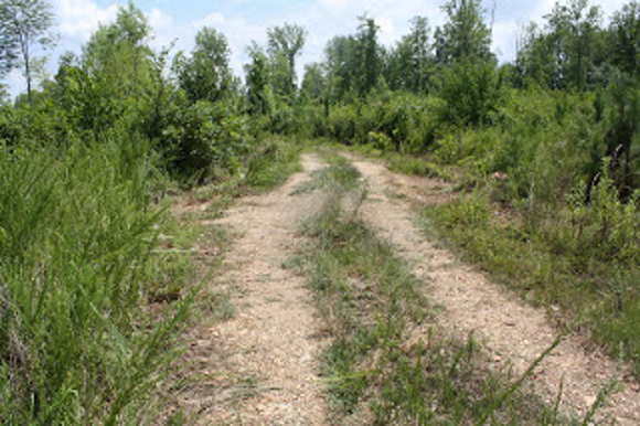
The Cedartown to Cabin Spring trail. Image source: http://trailofthetrail.blogspot.com/2010/08/driving-tour-trail-of-tears-from.html
The driving path can be picked back up on Banks Mountain Road. For about 6/10th of a mile, after turning right (east) onto Banks Mountain Road from Cave Spring Road, the scenic Banks Mountain Road appears to be highly congruent with the original Cherokee-era road. It seems to veer to the south a bit at about the .63 mile marker, but still run parallel with Banks Mountain Road until the top of the hill (N 34’04.768 / W 85’19.503). The dirt road is fenced off, but it appears to continue south, back toward Cedartown, joining with the original Cherokee-era road a little less than a mile south of the fence. Going back down the hill to Cave Spring Road, turning right (north), the road changes its name to the “Old Cedartown Road,” heading into Cave Spring. This marks the beginning of a nearly 10-mile stretch between Cave Spring and Cedartown where today’s roads basically runs along the same path the Cherokees traveled in the early 19th century.
Sources:
Image source: https://www.waymarking.com/waymarks/WMKZVA_
Trail_of_Tears_Removal_Camp_Cedartown_Georgia
http://trailofthetrail.blogspot.com/2010/08/driving-tour-trail-of-tears-from.html
Data about the encampment at Cedar Town (as it was then spelled) was located in the
quartermasters’ records in the National
Archives, the governors’ correspondence in the
Georgia Department of Archives and History,
and the microfilm collections of removal records
at the National Archives Records Administration
in East Point, Georgia. The Special Collections
of the Hargrett Library at the University of
Georgia contain the military records of Capt.
Isaac S. Vincent, commander at Cedar Town,
and those records have been copied to the online
collection of Documents Relating to
Southeastern Indians that is currently accessed
through Galileo. Although the documents
consistently refer to the camp at Cedar Town,
they give no information about its specific
location.
Three local contacts were particularly
helpful: Kevin McAuliff of the North Georgia
Regional Development Center in Dalton, Mike
Wyatt of the Historic Preservation Committee in
Cedartown, and Bill Blankenship, president of
Ft. Mountain Preservation Services. McAuliff
believes the encampment site was at Charley
Town (also spelled Char le Town, Charlie
Town) because a substantial number of whites
lived in Cedar Town by the time of removal. All
correspondence found for the encampment refers
only to Cedar Town, but such identification may
not be meaningful. It may, for example, refer to
the post office location.
http://sites.rootsweb.com/~itcherok/history/forts-removal.htm
Hill, Sarah H. Cherokee Removal: Forts Along the Georgia Trail of Tears. The National Park Service and the Georgia Department of Natural Resources/Historic Preservation Division. 2011.
Henderson, Dr. Charles K. Polk County History. 1897, chapter 3 p. 1.
1842 Cherokee Claims
Saline District, comp. by Marybelle Chase, 12, 15,
16, 18, 20, 22-4, 27, 28, 31, 55, 68, 72.
GDAH, Cherokee Letters Talks Treaties, Vol. 3,
654.
GDAH RG 1-1-5 Box 19.
NARA RG 393 m1475 r1 fr 0283.
GDAH Cherokee Letters Talks Treaties vol. 3
722.
NARA RG 393 m1475 r1 fr 0372-73.
NARA RG 393 m1475 r1 fr 0572-74.
GDAH, RG 1-1-5, Box 19.
NA RG 92 Entry 357 Box 6.
NARA RG 393 m1475 r1 fr 0260-62.
NARA RG 393 m1475 r1 fr 0209-11.
Isaac S. Vincent Papers, Mss. 617, Folder 6,
Hargrett Library, University of Georgia Libraries,
Athens.
May, 1838, Miller Grieve, Milledgeville, to
Capt. Isaac S. Vincent, http://neptune3.galib.uga.edu,
15 March, 2001.
NARA RG 393 m1475 r1 fr 0363.
Feb. 5, 1839, Augustus H. Stokes, Newton, to
Isaac Vincent, http://neptune3.galib.uga.edu, 7 July,
2002.
NA RG 92 Entry 350 Box 2 Vol 2 215-216.
NARA RG 393 m1475 r1 137.
NARA RG 393 m21475 r1 fr 0351-53.
May 20, 1838 Headquarters Eastern Division,
Order 30 http://neptune3.galib.uga.edu, 7 July, 2002.
May 28-June 26, 1838, Cedar Town Provision
Returns, http://neptune3.galib.uga.edu, 7 July, 2002.
NARA RG 393 m1475 r1 fr 0637-39.
June 14, 1838, Gen. Floyd, Cedar Town, to
Capt. Isaac Vincent, http://neptune3.galib.uga.edu, 7 July, 2002.
>